The Athabasca Basin and Industrial devleopment
|
The Athabasca basin crosses the province of Alberta, draining from the central western border to the northeast Peace River Delta, a UNESCO World Heritage Site. The river and delta are vital grounds for migratory waterfowl and fish. Additionally, these resources are used as food and water sources for more than 150,000 people. Potential contamination from upstream sources must be diligently assessed, managed, and mitigated where necessary to ensure these resources remain safe and sustainable. The focus of this study is to examine the Polycyclic Aromatic Hydrocarbons (PAH) fingerprints of potential contamination to determine the source. Source determination has the potential to guide future management strategies.
oNGOING mONITORINGThe focus of monitoring efforts has occurred north of Fort McMurray in the Athabasca Oilsands Region (AOSR) (see adjacent map). In the AOSR, approximately 9,100km2 of land has been leased for oilsands industry and is under some degree of active development. Data collection to safeguard these resources began in 1997 and continues to-date. While there has been continuous monitoring, focus and operating practices have shifted based on changes in legislation, funding, partnerships, and expert recommendations. Data for this statistical approach includes information from only the latest iteration, the Oilsands Environmental Monitoring Program (OSM) as changes in technology and sampling procedures may bias results.
|

Figure 1. Location of AOSR in Alberta with major drainage basins included.
|
Oilsands monitoring project - 2015-Present
Funding was initiated through the Oil Sands Environmental Monitoring Program Regulation in 2013 with a total budget of $50 million per year. This is provided by industry to complete hydrological, ecological, and biological research objectives. The aquatics program is reviewed periodically to streamline and refocus research to ensure the data collected is both accurate and of sufficient value to understand ecohydrological conditions. The last report was issued in 2018 with a decision tree for determining which sites will be included in future monitoring and is included (see "Sampling methods and Analysis").
rEGIONAL aQUATICS mONITORING PROGRAM (ramp) - 1997-2015
RAMP was initiated in 1997 as a collaborative effort between Government, First Nations Communities, and Industry Members. The program was solely industry funded and reports were submitted annually to Alberta environment and Parks (AEP) and Environment and Climate Change Canada (ECCC). In 2004 and 2010 the program underwent a peer review to ensure data collection and reporting was relevant. These reviews raised questions relating to the efficacy of the program. This includes issues regarding the programs ability to detect impacts and changes. Additional issues included a lack of transparency in data collection, assessment, and reporting. The program continued to 2012 where it began to merge with the new Joint Canada-Alberta Oil Sands Monitoring Program, the multilevel government initiative detailed above and designed to objectively assess the effects of the oilsands industry in Northeastern Alberta.
PolyCyclic Aromatic Hydrocarbons
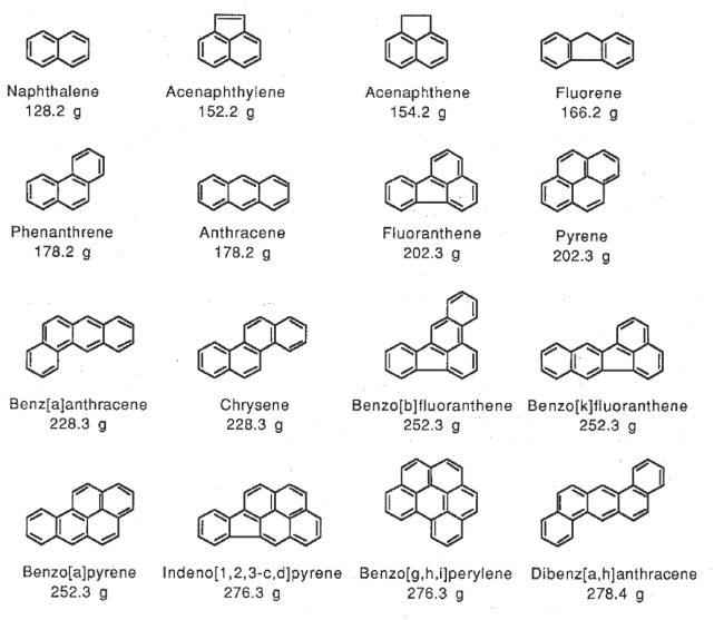
Figure 2. Chemical structure of the 16 PAH compounds listed by the American Environmental Protection Agency as priority pollutants.
|
PAHs are hydrocarbons which are bound into multiple aromatic rings with double bonds. These compounds are hydrophobic and tend to accumulate in highest concentrations in soils or on suspended sediments. PAHs bioaccumulate in invertebrates and tadpoles but can be processed more readily in adult fish and humans, reducing ongoing accumulation effects. Regardless, PAHs are known to cause reduced offspring survival and deformations of fathead minnows, and are carcinogenic to humans. While instream concentrations of individual compounds may be under guidelines, the sum of the concentrations may yet cause negative health affects in animals.
|
PAHs are generated and released into the environment from both anthropogenic and natural sources.
Anthropogenic sources include:
Anthropogenic sources include:
- combustion (wood, coal, petroleum products)
- bitumen upgrading and refining
- accidental releases
- forest fires
- natural oilsands outcrop seepages and erosion (McMurray formation)
- organic decomposition
oBJECTIVES
The ambiguity of the sources responsible for higher concentrations of these compounds presents difficulties with enacting effective management strategies. Research indicates a relationship between PAH source and the relative concentrations of the compounds. Production of PAHs through combustion generally produces relative concentrations in the order of C0>C1>C2>C3>C4. Whereas petrogenic sources typically have a bell or right bias (i.e., C0<C1<C2=C3>C4, or C0<C1<C2<C3<C4). Based on these characteristics, divisive clustering may be able to differentiate PAH sources. This may allow us to determine areas most impacted by industry and predict the timing of these releases. If successful, the PAH fingerprint could help focus management efforts spatially and temporally in mitigating environmental impacts from industry.
Expected resultsIf the fractionation signatures are present, expected PAH fingerprints downstream of the McMurray formation and petroleum industries should have distinctly different signatures to undeveloped areas. As PAHs are hydrophobic and accumulate in soils and snowpack, the expectation would be that distinct signature differences would occur during periods of rapid snowmelt and other high flow events with enhanced erosion.
Other considerations may dominate or confuse these signatures. PAH fingerprints resulting from atmospheric loading may be impacted by dominant wind directions. Coke, tailings ponds, and other petrogenic byproducts from industry are stored at surface in these areas. 2015-2022 climate data from three local stations show the general wind direction trends N<->S/SW in winter and spring. Elevated PAH concentrations observed in tributaries to the Athabasca River may be the result of natural erosion of the bitumen rich McMurray formation. As this is a petrogenic source, rivers which downcut into this formation may have a naturally enhanced signature. |
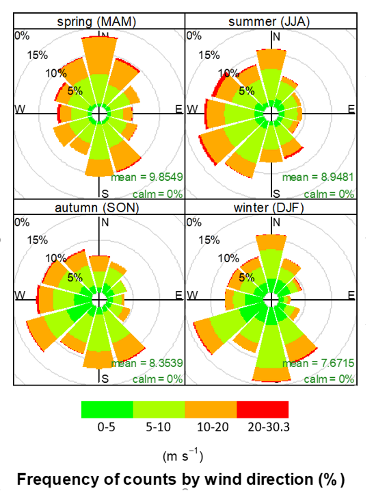
Figure 3. A wind rose showing the predominant wind direction in the AOSR, compiled from three different weather stations in the region.
|
